Showing posts with label APHuG. Show all posts

Tuesday, May 28, 2013

Tornado: Part Five

As I pulled into the driveway at Southmoore on Friday morning something colorful caught my attention.  I saw a large amount of yellow shirts on the side of our building...with rakes, shovels, trash bags, etc.  They were helping to clean our grounds of the debris from the peripheral winds of the tornado.  I did make my way out to where they were working so as to learn who this group was.  Interestingly enough I noticed that it wasn't just yellow shirts, but there were also many people wearing purple...there were actually TWO volunteer groups.  The purple clad blessings were part of a national disaster recovery team called DRAW: Disaster Relief at Work; this specific group was a based out of a Michigan community near Detroit.  The yellow clad blessings were part of a national disaster relief team affiliated with the Church of Jesus Christ of Later Day Saints; these "Mormon Helping Hands" include LDS missionaries from all over the U.S. and they were joined today by one of Southmoore's own wonderful LDS families...the Beans!!  Both groups worked long and hard to help beautify our grounds!
DRAW: Disaster Relief at Work (Team Purple)

Mormon Helping Hands (Team Yellow)

Mormon Helping Hands (Team Yellow)

The Bean Family working with Mormon Helping Hands
(Justin, Shawn, Gordon, Shauna, Erin, & Jourdon)
Friday morning was filled with a bunch of "end of year" procedures and clean-up which are part of our usual duties as teachers.  However, no computer network, internet, e-mail, or grade-book access complicated much of this [smile].  I did get as much packed and cleaned up as possible, which included boxing up LOTS of textbooks as this is the end of the adoption cycle for Social Studies textbooks.

The remainder of the day involved some relief/outreach projects which actually began getting planned on Tuesday.  While I was at Norman High School on Tuesday (see Tornado: Part Two) I began receiving some text messages from a friend and colleague with Union Public Schools (Tulsa area).  Philippa Kelly and I have gotten to know each other over the past several years as teachers of AP Human Geography and this relationship has grown since I began my involvement with Student Council.  Philippa is currently the director/coordinator of all student activities at Union High School.  She was contacting me so serve as a local coordinator for delivery of a host of items being donated as part of a relief drive in Union P.S.  We texted and called each other over the next few days and Friday afternoon was the time we scheduled for delivery.

I met up with Philippa and Eli Huff, one of her colleagues from Union, before their arrival to First Baptist Church in Moore.  Due to the interstate route they were planning, along with FBC already being a primary donation drop-off point, we had decided to make the drop here.  As we pulled in to the unloading area we were informed that they did not need anymore bottled water as their supply was already too large so we verbally mentioned that we would take it on down to Southmoore.  As they heard us talking about going to another relief center they asked if we could take more water and some clothing and stuffed animals with us.  Philippa and Eli agreed.  So after unloading many other supplies, including personal hygiene products, baby diapers, and baby formula we took on our agreed upon load.


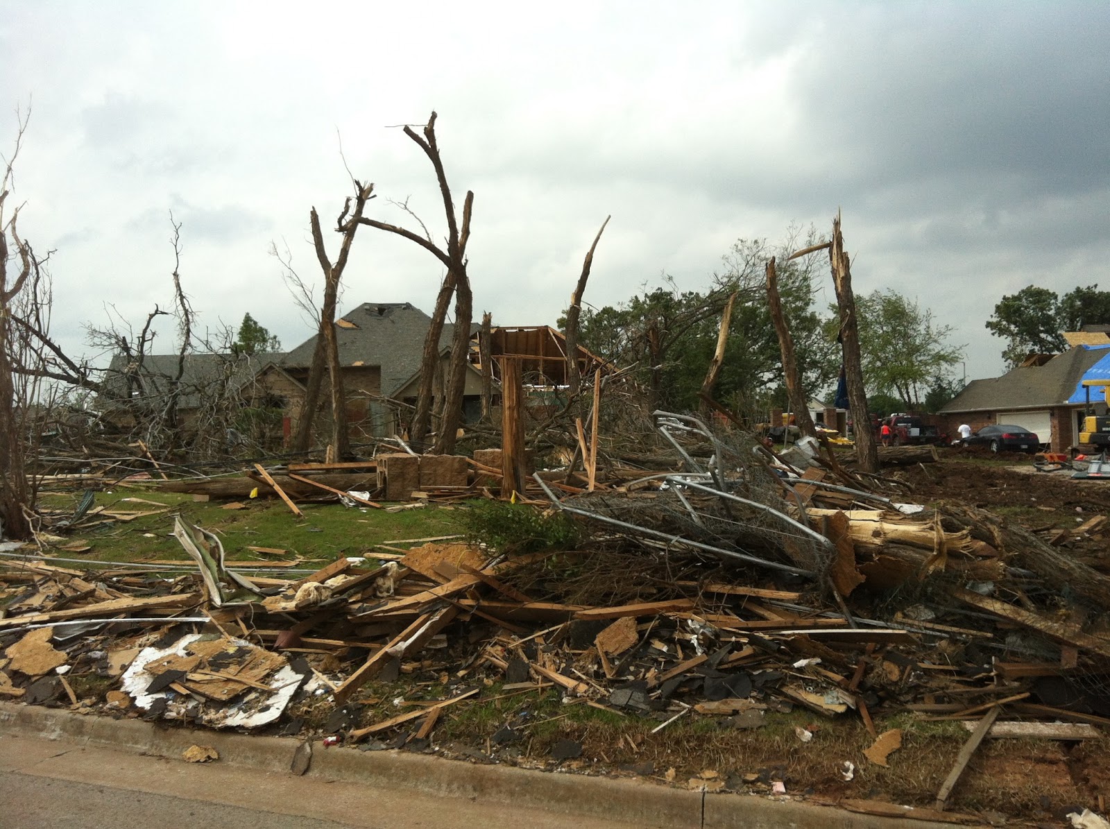
We then began the navigation process toward Southmoore.  Due to repair to electric lines and other utilities, some of the main roads which had become open following the clearing of major debris were now re-closed. So the route was a major weaving around.  Somehow we ended up driving west 4th Street between Sunnylane and Eastern Avenue and then south on Eastern Avenue toward 19th Street...the heart of much of the devastation which occurred east of I-35.  While not the best route for trying to get to Southmoore rapidly it ended up being an important visual image to all three of us on the importance of the relief work that Union P.S. (and so many other schools and organizations around) were doing.


Union Public Schools' Eli Huff & Philippa Kelly
In a mad dash of unloading items into Southmoore, the representatives from the Moore Council PTA who were overseeing the SHS based relief center were just amazing by the efforts of Union's power team to not only bring items for relief, but to also help shuffle items from one relief center to another.  Members of those yellow clad "Mormon Helping Hands" also helped to unload the supply van.  Philippa and Eli had to leave all too soon so as to get the borrowed van back to Tulsa on time.

I continue to be so blessed by ALL of the various groups who are actively providing their love and support.  I've received so many messages contacting me: from Broken Arrow, OK, to Nevada, to Utah, and even to an agriculture education team at a school in Texas who were concerned about meeting the needs of the animals in Moore's ag. ed. program.  SIMPLY OVERWHELMED WITH BLESSING!!

Tuesday, January 29, 2013

When I think of "Agriculture"...

Today, my AP Human Geography began our unit on Agriculture and Rural Use of Land.  To help "inspire" them to begin thinking about that which is connected to agriculture, I showed a couple of music videos from the employees of Peterson Farm and Livestock in Assaria, Kansas.  These videos parody songs from pop culture and yet give a very pro-agriculture message.

"I'm Farming and I Grow It" (parody of "I'm Sexy and I Know It")

"Farming Style" (parody of "Gangnam Style")

We followed this up with each student responding, via polleverywhere.com, to the prompt "When I think of "agriculture", I think of ...".  Students were asked to respond with a minimum number of terms or phrases.  Here is a word cloud (generated at wordle.net) of their responses.
I know that most of my students' responses link to stereotypes based on where they live (country and region in country).  As we study this unit, a remote road for most of my suburban kids, I hope that they are able to understand how agriculture encompasses so much more than the farms of "middle America".  This could be fun!

Saturday, December 15, 2012

To my students...

By now I'm sure that most of you have heard about the events which occurred yesterday at Sandy Hook Elementary School in Newton, Connecticut.  I'm sure that like most of us, your minds are racing with all kinds of questions on a variety of social, political, religious, and possibly even economic topics which are related to the events of yesterday.  Having such questions, having emotional reactions, are natural and you should not be discouraged from having them.

My purpose in writing to you today is to let each and everyone of you know that I love you.  I value each of you as a special gift that God gave to this world and that has been entrusted into my educational care for a brief period of your life.  I may not always be happy with your performance in class, your less than stellar behavior, or the fact that you sometimes don't realize your own potential for life.  However, I will always love you.  Even if I get aggravated at times, I will always love you and I pray daily for you to obtain the best that life has to offer.

While you are under my care and watchful eye, this love for you compels me to unquestionablly seek your protection from harm.  I will do my best to make sure that while you are in school, especially within my classroom, that you are safe.  And if need be, I would even put myself in harm's way to help save you ... each of you.

So even while you think of yesterday's events, while you see the images, while you express your emotions, know that you will be as safe as I can possibly make you while you are in my care.

Also ... do your homework this weekend <wink>.  After all, APHuG has the multiple choice portion of their Unit Three Test (Cultural Geography) and APUSH has the essay portion of their Unit Six Test (Civil War and Reconstruction).

See you Monday!!

Monday, July 23, 2012

Teaching at Krida

Today was our first full day at Krida Nusantara. After breakfast, without students due to their Ramadan fasting, Daniel and I attended the morning "Roll Call". This is a time for the principal to give special daily announcements to the faculty and to have a morning prayer. The principal introduced us to his faculty and as I greeted them I gave the principal a letter of greeting which had been prepared by Lt. Governor Todd Lamb as well as an Oklahoma flag sent as a gift from my principal, Roy Smith, from Southmoore. We were then off to class time with students.

Betty had arranged for Daniel to teach in English classes and for me to teach in geography classes. Our teaching topic, which was assigned prior to our arrival in Indonesia, was "American Culture". I used both my Oklahoma prezi and postcards from my Southmoore APUSH & APHuG students as a way to engage the students at Krida in discussions about life in the Sooner (and Cowboy) State. There were several points in which we were able to express similarities between Oklahoma and Indonesia: for example, both locations have experienced the impact of terrorism. Finding common ground and similar experiences is one of the great ways to build bridges over those things that separate cultures.

Following the four 70-minute class sessions, Daniel and I retired to the guest house for lunch and a brief rest. In the time we've each been enjoying our summer breaks, our bodies have forgotten how tiring a day of teaching can be...and then add to that the obstacles of cross-cultural and language interaction, the humidity in the non air conditioned classrooms, and the lack of ability to take a drink during class time due to Ramadan. We were both TIRED.

Betty then arranged for a late afternoon to evening adventure in the city. We went to one of the local malls to see the new Batman movie. The next showing was sold out so we walked around the mall until the our show would start. While shopping I'm discovering that it may be very difficult fore to find a Batik shirt that will fit; Indonesians are just not as big as I am, LOL. The tickets for the movie were for specific seats in the theater...Betty did great at picking these out.

Following the movie and en route back to the Krida campus, we stopped for dinner. This was such a great feast of lamb sate and rice; I could get used to skewers of lamb or chicken sate with peanut and soy sauces or dipping.

As noted yesterday, the wifi connection is not strong so I will post pictures as soon as I able.

Monday, July 16, 2012

Donations-a-Plenty

In preparation for my Teacher for Global Classrooms trip to Indonesia, I asked LOTS of people, organizations, businesses, cultural groups, etc., to donate items for me to give out to those whom I meet in Indonesia, especially the students at the schools I will be visiting.  Let's just say "I'm blown away!!!"

Here's a sampling of what I am trying to squeeze into a rolling duffel bag and yet not exceed the 50 lbs weight limit...

From a variety of school clubs & sports teams at Southmoore High School
~Freshman Class, Junior Class, Senior Class, Student Council,
Speech & Debate, National Honor Society, Soccer, Track & Field,
SuperCats, Administration, Yearbook, & AP Human Geography~
Donations included t-shirts galore, sweat pants, sunglasses, foam spirit fingers,
key chains from our first prom, the 2011-2012 Yearbook, and a 3x5 Oklahoma Flag

From the Oklahoma City National Memorial & Museum
Pencils and "Character" lapel pins

From the National Cowboy & Western Heritage Museum
Pencils and bookmarks featuring horses

From the Oklahoma Department of Libraries
bookmarks with pictures of Oklahoma's history

From the Oklahoma City RedHawks baseball team
baseball hats, t-shirts, pencil bags, blankets, pennate flags, and note pads


From the Oklahoma City Thunder basketball team
insulated lunch bags, peel-n-stick patches, rulers, pencil bags (with sharpener, pencils, eraser, & ruler), rubber wrist bands, rubber wrist watches, and lapel pins

In addition to these gifts, I also have 400+ hand written postcards from the students at Briarwood and Oakridge elementary schools and my AP US History and AP Human Geography students.

I am so thankful to each of these organizations for their generosity and I look forward to sharing pictures of the students and other individuals who will become recipients of these wonderful "Oklahoma" treasures.

Friday, July 6, 2012

Indonesia: Urban Geography

Indonesia
An Urban Geography Profile

  • Largest City: Jakarta
    • Rank Size Rule Population Estimate: 9,751,937
      • Actual Population: 9,751,937
  • 2nd Largest City: Surabaya
    • Rank Size Rule Population Estimate: 4,875,969
      • Actual Population: 2,814,867
  • 3rd Largest City: Bekasi
    • Rank Size Rule Population Estimate: 3,250,646
      • Actual Population: 2,581,539
  • 4th Largest City: Bandung
    • Rank Size Rule Population Estimate: 2,437,984
      • Actual Population: 2,488,390
  • 5th Largest City: Medan
    • Rank Size Rule Population Estimate: 1,950,387
      • Actual Population: 2,162,805

To what extent is the Rank Size Rule shown to be valid or invalid based upon the population information for your country?
The Rank Size Rule suggests that the 2nd largest city in a country will be about half the size of the population of the country's largest city, the 3rd largest city will be about 1/3 the size of the largest city, so on and so forth such that the N largest city would be 1/N the size of the largest city's population.  The actual populations for Indonesia's 2nd, 3rd, 4th, and 5th largest cities are much closer together than they should be according to the estimates of the Rank Size Rule.  There is little, if any evidence, would could be used to support a claim that the Rank Size Rule is valid for Indonesia. Jakarta's situation is better defined as a primate city due to being disproportionately larger than other cities (proportion as suggested by the Rank Size Rule).

Population: 238,181,000
Population Density: 125 people per sq km
% Urban Population: 43%
% Urban Population Living in Slums: 26%
Average Annual % Change in Urban Population: 3.3%
% with Improved Urban Sanitation: 67%
% with Improved Urban Water Supply: 89%

Information from World Gazetteer and the Population Reference Bureau

Honduras: Urban Geography

Honduras
An Urban Geography Profile

  • Largest City: Tegucigalpa
    • Rank Size Rule Population Estimate: 1,135,309
      • Actual Population: 1,135,309
  • 2nd Largest City: San Pedro Sula
    • Rank Size Rule Population Estimate: 567,655
      • Actual Population: 687,018
  • 3rd Largest City: Choloma
    • Rank Size Rule Population Estimate: 378,436
      • Actual Population: 260,439
  • 4th Largest City: La Ceiba
    • Rank Size Rule Population Estimate: 283,827
      • Actual Population: 189,078
  • 5th Largest City: El Progreso
    • Rank Size Rule Population Estimate: 227,062
      • Actual Population: 141,007

To what extent is the Rank Size Rule shown to be valid or invalid based upon the population information for your country?
The Rank Size Rule suggests that the 2nd largest city in a country will be about half the size of the population of the country's largest city, the 3rd largest city will be about 1/3 the size of the largest city, so on and so forth such that the N largest city would be 1/N the size of the largest city's population.  While the Rank Size estimates for San Pedro Sula, Choloma, La Ceiba, and El Progreso do not match up exactly with the actual populations of each city, there is some validity to the use of the Rank Size Rule in estimating the population of Honduras' cities.  Despite the populations not fitting exactly, one can see a general decline in the population ratios of each city as compared to Tegucigalpa which resemble the trend suggested by the Rank Size Rule.

Population: 7,754,700
Population Density: 69 people per sq km
% Urban Population: 52%
% Urban Population Living in Slums: 35%
Average Annual % Change in Urban Population: 2.9%
% with Improved Urban Sanitation: 80%
% with Improved Urban Water Supply: 95%

Information from World Gazetteer and the Population Reference Bureau

Thursday, July 5, 2012

Honduras: Development & Industry

Honduras:
A Development & Industry Profile

Population: 7,754,700
CO2 Emissions per Capita: 1.0 metric tons
% Women as Non-Farm Wage Earners: 34%

Human Development Index: 0.667
# of TVs per Capita: 0.074
# of Physicians per 1000 people: 0.57
Medical Spending per Capita (in US$): $107.33
Education Spending (% of GDP): N/A
Pupil-Teacher Ratio (Secondary Level): N/A

% of GDP as Industry: 26.3%
Total Labor Force: 3.461 million
% of Labor Force in Industry: 20.9%
Unemployment Rate: 4.8%
Public Debt (% of GDP): 29.6%
Inflation Rate: 7%

Industries:
sugar, coffee, woven and knit apparel, wood products, cigars

Electricity Production: 6.58 billion kWh
Electricity Consumption: 6.54 billion kWh
Oil Production: 0 bbl/day
Oil Consumption: 51,000 bbl/day
Natural Gas Production: 0 cu m
Natural Gas Consumption: 0 billion cu m

Value of Exports: $6.839 billion
Export Partners and %:
U.S. (65%), El Salvador (4.4%), Germany (4%)

Value of Imports: $10.04 billion
Import Partners and %:
U.S. (50.7%), Guatemala (8.2%), Mexico (5.3%), El Salvador (4.8%)

# of Internet Hosts: 27,074
# of Internet Users: 731,700
# of Airports (total): 104
# of Airports with Paved Runways: 13
# of km of Roadways (total): 14,239 km
# of km of Paved Roadways: 3,159 km
# of km of Waterways: 465 km
Location of Ports & Terminals:
La Ceiba, Puerto Cortes, San Lorenzo, Tela

Information from Population Reference Bureau, NationMaster.com, and the CIA's Worldfact Book.

Indonesia: Development & Industry

Indonesia:
A Development & Industry Profile

Population: 238,181,000
CO2 Emissions per Capita: 1.5 metric tons
% Women as Non-Farm Wage Earners: 32%

Human Development Index: 0.697
# of TVs per Capita: 0.058
# of Physicians per 1000 people: 0.13
Medical Spending per Capita (in US$): $41.77
Education Spending (% of GDP): 1.2%
Pupil-Teacher Ratio (Secondary Level): N/A

% of GDP as Industry: 47.2%
Total Labor Force: 117.4 million
% of Labor Force in Industry: 12.8%
Unemployment Rate: 6.6%
Public Debt (% of GDP): 24.5%
Inflation Rate: 5.7%

Industries:
petroleum and natural gas, textiles, apparel, footwear, mining, cement, chemical fertilizers, plywood, rubber, food, tourism

Electricity Production: 141.2 billion kWh
Electricity Consumption: 126.1 billion kWh
Oil Production: 1.03 million bbl/day
Oil Consumption: 1.292 million bbl/day
Natural Gas Production: 82.8 billion cu m
Natural Gas Consumption: 40.47 billion cu m

Value of Exports: $208.9 billion
Export Partners and %:
Japan (16.3%), China (10%), U.S. (9.1%), Singapore (8.7%), South Korea (8%), India (6.3%), Malaysia (5.9%)

Value of Imports: $172.1 billion
Import Partners and %:
China (15.1%), Singapore (14.9%), Japan (12.5%), U.S. (6.9%), Malaysia (6.4%), South Korea (5.7%), Thailand (5.5%)

# of Internet Hosts: 1.342 million
# of Internet Users: 20 million
# of Airports (total): 676
# of Airports with Paved Runways: 185
# of km of Roadways (total): 437,759 km
# of km of Paved Roadways: 258,744 km
# of km of Waterways: 21,579 km
Location of Ports & Terminals:
Banjarmasin, Belawan, Kotabaru, Krueg Geukueh, Palembang, Panjang, Sungai Pakning, Tanjung Perak, Tanjung Priok


Monday, June 25, 2012

Indonesia: Agricultural Profile

Indonesia:
An Agricultural Profile

Total Area: 1,904,569 sq km
Land Area: 1,811,569 sq km
Water Area: 93,000 sq km

Climate:
tropical; hot, humid; more moderate in highlands

Terrain:
mostly coastal lowlands; larger islands have interior mountains

Arable Land Use: 11.03%
Permanent Crop Use: 7.04%
Irrigated Land: 67,220 sq km
Total Renewable Water Resources: 2,838 cu km
Total Freshwater Withdrawal: 82.78 cu km per year
Per Person Freshwater Withdrawal: 372 cu m per year

Natural Hazards:
occasional floods; severe droughts; tsunamis; earthquakes; volcanoes; forest fires

Current Environmental Issues:
deforestation; water pollution from industrial wastes, sewage; air pollution in urban areas; smoke and haze from forest fires

Total Labor Force: 117.5 million
% Agricultural Labor Force: 38.3%

Agricultural Products:
rice, cassava (manioc), peanuts, rubber, cocoa, coffee, palm oil, copra; poultry, beef, pork, eggs


Information from CIA's World Factbook

Honduras: Agricultural Profile

Honduras:
An Agricultural Profile

Total Area:112,090 sq km
Land Area: 111,890 sq km
Water Area: 200 sq km

Climate:
subtropical in lowlands, temperate in mountains

Terrain:
mostly mounains in interior, narrow coastal plains

Arable Land Use: 9.53%
Permanent Crop Use: 3.21%
Irrigated Land: 800 sq km
Total Renewable Water Resources: 95.9 cu km
Total Freshwater Withdrawal: 0.86 cu km per year
Per Person Freshwater Withdrawal: 119 cu m per year

Natural Hazards:
frequent, but generally mild earthquakes; extremely susceptible to damaging hurricanes and floods along the Caribbean coast

Current Environmental Issues:
urban population expanding; deforestation results from logging and the cleaning of land for agricultural purposes; further land degradation and soil erosion hastend by uncontrolled development and improper land use practices such as farming of marginal lands; mining activities polluting Lago de Yojoa (the country's largest source of fresh water), as well as several rivers and streams, with heavy metals

Total Labor Force: 3.461 million
% Agricultural Labor Force: 39.2%

Agricultural Products:
bananas, coffee, citrus, corn, African palm, beef, timber, shrimp, tilapia, lobster


Information from CIA's World Factbook

Saturday, June 23, 2012

Honduras: Political Profile

Honduras:
A Political Profile

Country's Name: Republic of Honduras
Capital City: Tegucigalpa
Type of Government: democratic constitutional republic
Independence Date: September 15, 1821 (from Spain)

Chief of State (public face): President Porfirio Lobo Sosa
Head of State (actual leader): President Porfirio Lobo Sosa

Description of Executive Powers:
President (who serves as both Chief of State and Head of State) and Vice President are elected by popular vote for a four-year term; the last election was held on November 29, 2009 with the next to be held in November 2013. Additionally, the President appoints a Cabinet.

Description of Legislative Powers:
A unicameral National Congress (Congreso Nacional) with 128 seats; members are elected proportionally by the various departments to serve a four-year term.  The last elections were held on November 29, 2009 with the next to be held in November 2013.

Description of Judicial Powers:
The Supreme Court of Justice (Corte Suprema de Justicia) has 15 judges which are elected for seven-year terms by the National Congress.

Suffrage (voting rights): 18 years of age; universal and compulsory

Their Ambassador to U.S.: Jorge Ramon Hernandez Alcerro
Location of Embassy in U.S.: Washington, DC
Location of Consulates in U.S.: Atlanta, Chicago, Houston, Los Angeles, Miami, New Orleans New York, Phoenix, and San Francisco (honorary in Jacksonville)

U.S. Ambassador to Them: Lisa J. Kubiske
Location of U.S. Embassy There: Tegucigalpa
Location of U.S. Consulates There: none

Representative to the UN: Mary Elizabeth Flores Flake

three equal horizontal bands of blue (top), white (middle), and blue (bottom), with five blue five-pointed stars arranged in an "X" pattern centered in the white band; the stars represent the members of the former Federal Republic of Central America (Costa Rica, El Salvador, Guatemala, Honduras, and Nicaragua); the blue bands symbolize the Pacific Ocean and the Caribbean Sea; the white band represents the land between the two bodies of water and the peace and prosperity of its people

Indonesia: Political Profile

Indonesia:
A Political Profile

Country's Name: Republic of Indonesia
Capital City: Jakarta
Type of Government: republic
Independence Date: August 17, 1945 (from the Netherlands)

Chief of State (public face): President Susilo Bambang Yudhoyono
Head of State (actual leader): President Susilo Bambung Yudhoyono

Description of Executive Powers:
President (who serves as both Chief of State and Head of State) and Vice President are elected for five-year terms (eligible for a second term) by direct vote of the citizenry; the last election was held on July 8, 2009 with the next to be held in 2014.  Additionally, the President appoints a Cabinet.

Description of Legislative Powers:
The People's Consultative Assembly (Majelis Permusyawaratan Rakyat or MPR) is the upper house; it consists of members of the DPR and DPD and has a role in inaugurating and impeaching the President and in amending the constitution but does not formulate national policy.  The House of Representatives (Dewan Perwakilan Rakyat or DPR) has 560 seats and its members are elected to serve five-year terms.  The DPR formulates and passes legislation at the national level.  The House of Regional Representatives (Dewan Perwakilan Daerah or DPD) has the constitutionally mandated role of providing legislative input to the DPR on issues affecting the country's various regions (132 members, four from each of Indonesia's 30 provinces, two special regions, and one special capital city district).  The last elections were held on April 9, 2009 with the next to be held in 2014.

Description of Judicial Powers:
The Supreme Court (Mahkamah Agung) is the final court of appeal but does not have the power of judicial review.  Justices are appointed by the President from a list of candidates selected by the legislature.  In March of 2004 the Supreme Court assumed administrative and financial responsibility for the lower court system from the Ministry of Justice and Human Rights.  The Constitutional Court (Mahkamah Konstitusi) has the power of judicial review, has jurisdiction over the results of the general elections, and reviews actions to dismiss a President from office.

Suffrage (voting rights): 17 years of age; universal
all married persons regardless of age

Their Ambassador to U.S.: Dino Patti Djalal
Location of Embassy in U.S.: Washington, DC
Location of Consulates in U.S.: Chicago, Houston, Los Angeles, New York, and San Francisco

U.S. Ambassador to Them: Scot A. Marciel
Location of U.S. Embassy There: Jakarta
Location of U.S. Consulates There: Surabaya, with presence in Medan and Bali

Representative to the UN: Desra Percaya

two equal horizontal band of red (top) and white (bottom); the colors derive from the banner of the Majapahit Empire of the 13th-15th centuries; red symbolizes courage and white represents purity


Friday, June 22, 2012

Indonesia: Culture Profile

Indonesia:
A Cultural Profile

Nationality:
Indonesian

Ethnic Groups:

Languages:
Bahasa Indonesia (official; a modified form of Malay), English, Dutch,
and local dialects (of which the most widely spoken is Javanese)

Religions:


Information from CIA's World Factbook

Honduras: Culture Profile

Honduras:
A Cultural Profile

Nationality: Honduran

Ethnic Groups:

Languages:
Spanish (official) with Amerindian dialects

Religions:


Information from CIA's World Factbook

Saturday, June 16, 2012

Honduras: Population Profile

Honduras:
A Population Profile

Population (Mid-2011): 7,754,700
Land Area (sq. km): 112,090
Population Density (per sq. km): 69
Net Migration (# per 100): -2

Crude Birth Rate (# per 1000): 26
Crude Death Rate (# per 1000): 5
Rate of Natural Increase: 2.1%
Infant Mortality (# deaths per 1000 births): 24.0
Total Fertility Rate (av. # born per woman): 3.1
Dependency Rate (<age 15% + >age 65%): 36% + 4% = 40%
Male Life Expectancy: 71 years
Female Life Expectancy: 76 years

Male Literacy Rate: 93%
Female Literacy Rate: 95%
% Male Enrolled in Secondary School: 57%
% Female Enrolled in Secondary School: 72%

GNI PPP per capita (in US$): $3,710
% Living Below US$2 Per Day: 36%
% Male 15+ Economically Active: 80%
% Female 15+ Economically Active: 40%
Mobile Phone Accounts (# per 100): 85
Motor Vehicles (# per 1000): N/A

% Women in Legislative Body: 18%

% Rural with Access to Improved Water: 77%
% Undernourished: 23.0%
% Children <age 5 Underweight: 9.0%
% HIV/AIDS Among Ages 15-49: 0.8%

Indonesia: Population Profile

Indonesia:
A Population Profile

Population (Mid-2011): 238,181,000
Land Area (sq. km): 1,904,569
Population Density (per sq. km): 125
Net Migration (# per 100): -1

Crude Birth Rate (# per 1000): 19
Crude Death Rate (# per 1000): 6
Rate of Natural Increase: 1.3%
Infant Mortality (# deaths per 1000 births): 30.0
Total Fertility Rate (av. # born per woman): 2.3
Dependency Rate (<age 15% + >age 65%): 28% + 6% = 34%
Male Life Expectancy: 69 years
Female Life Expectancy: 74 years

Male Literacy Rate: 97%
Female Literacy Rate: 96%
% Male Enrolled in Secondary School: 75%
% Female Enrolled in Secondary School: 74%

GNI PPP per capita (in US$): $3,720
% Living Below US$2 Per Day: 51%
% Male 15+ Economically Active: 86%
% Female 15+ Economically Active: 52%
Mobile Phone Accounts (# per 100): 62
Motor Vehicles (# per 1000): 42

% Women in Legislative Body: 18%

% Rural with Access to Improved Water: 71%
% Undernourished: 6.0%
% Children <age 5 Underweight: 20%
% HIV/AIDS Among Ages 15-49: 0.2%

Sunday, June 3, 2012

CNN...thank you!!

A special "thank you" to CNN for this article that relates what myself and nearly 11,000 high school and higher education colleagues are involved with for the next two weeks.  There are 1200 US History educators and 350 Chemistry educators reading exams in Louisville with me and I currently have friends reading in Cincinnati, Ohio and Kansas City, Missouri right now with other subject areas.  Next week I have even more friends headed off to Louisville, Cincinnati, Kansas City, and Salt Lake City, Utah for their turn.

June 6th Update:
Was able to connect with two AP Chemistry teachers from my school district: Valerie Ferguson from Moore High and Janice Willingham from Westmoore High.  Kind of cool that Moore Public Schools had all three high schools represented in Col. Sanders land at the same time.  Additionally, I was able to connect with a couple of friends from the OKC area who teach at Edmond Memorial High to watch the Thunder's final game against the San Antonio Spurs.  Special thanks to Kevin McDonald, AP English Language, and T.J. Dortch, AP Chemistry...THUNDER UP!

Monday, May 21, 2012

Westbrook = Remote Road Roamer

In my AP United States History classes I try to teach my students about "historiography".  Simply put, this fancy word describes the efforts of historians to play "connect the dots" with the facts from the past so as to help complete the picture of what "happened."  Here's a sample of some of my own recent "historiography":

FACT ONE: On March 8, 2012, I posted an entry on this blog titled "Holi Moli" in which I described a little bit about the Hindu holiday of Holi and how my AP Human Geography class participated in "celebrating" this day.  My entry included an image of my "Holi shirt" which we created.

FACT TWO: On May 16, 2012, The Oklahoman (daily paper in central Oklahoma) ran an article describing my upcoming TGC trip to Indonesia.  The article, in both the print and online versions, included a link to this very blog.

FACT THREE: On May 16, 2012, the Oklahoma City Thunder was involved in playing game two of the NBA playoff series with the Los Angles Lakers.  Game two was in Oklahoma City and, thus, the Thunder's team members were in town and would have had easy access to the Wednesday issue (in print or online) of The Oklahoman.

FACT FOUR: On May 19, 2012, following the Thunder's 103-100 defeat of the Los Angeles Lakers in game four of the series, Russell Westbrook of the Oklahoma City Thunder arrived at a press conference sporting a splatter paint shirt.

So, the "historiography"?  It must be easy to connect the dots of the above facts.  Russel Westbrook obviously reads The Oklahoman on a regular basis.  During his perusal of the paper on May 16 he must have read the article about my trip and then spent much of the morning reading through this blog.  While reading the blog he was dumbstruck with the "Holi Moli" entry and thought "that guy looks great in that shirt".  Thus, he went out and purchased a shirt inspired by my look.  Westbrook then proceeded to wear his Holi and Burton inspired look during the LA based press conference on May 19.  It is such an honor to have Russell Westbrook as a fellow roamer of remote roads!

Don't believe me?  Check it out...

Friday, May 4, 2012

Calling All Students!

One of the goals of the Teachers for Global Classrooms program is to get my students virtually involved within my trip to Indonesia.  Those TGC teachers who have already traveled to Ghana, Morocco, and Ukraine have had students interacting with their blogs, posting comments, responding to questions from students in the other country (questions and answers appearing in text and video formats), etc.  This has worked "well" for these 30+ teachers in that their trips were during the school year and they were able to recruit participation from their students in person up until the day before their departures.  This is not the same for most of those in the Brazil cohort or for any of those in the India and Indonesia cohorts; our trips are in June and July.

So we have to be more creative in our recruitment strategies and try to entice student participation before the current school year is over.  To help build some interest among the students I will have next year I have already prepared and sent the letter below to those who have pre-enrolled in my AP Human Geography course for next year.  If I can get them interested and even participating now, then I hope they will be actively involved while I am in Indonesia during the second half of July.  It will also enhance class discussions next year when we can relate topics in class to experiences from the trip.  By being active participants in this adventure, they will be able to be virtual roamers of remote roads!